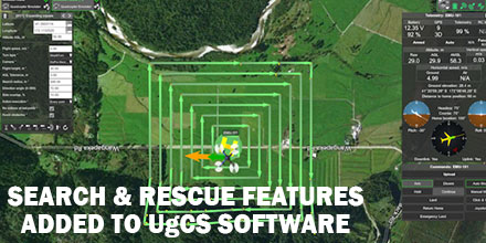
UgCS, provider of mission planning software for unmanned aircraft systems (UAS), together with public safety and disaster response UAS experts Airborne Response, developed a comprehensive search capability for drones.
The new feature allows remote pilots to more effectively conduct search and rescue operations using the UgCS platform.
Software Enhancements
The new enhancements provides users with a variety of quickly customizable search patterns. Such patterns include the “expanding square” and “creeping line” which can easily deploy in emergency and non-emergency situations.
Based on the flight altitude input by the operator, the UgCSsoftware automatically calculates key variables. These variable include, the course heading and track spacing necessary to provide the prescribed coverage area for a search target.
“The new enhancements to the UgCS mission planning software allow remote pilots, at every skill level, to quickly plan and implement a professional search mission with a UAS,” said Tom “Oaty” Oatmeyer, Chief Pilot at Airborne Response.
Expert Lends Expertise
Oatmeyer is an air rescue expert with 28 years of experience piloting helicopters for both the U.S. Air Force and the Miami-Dade Fire Rescue department.
Oatmeyer worked directly with the UgCS development team to bring the new features to fruition.
“The new UgCS search feature is designed to make searching for a target with a drone as simple and reliable as possible,” said Janis Kuze, Sales Director of SPH Engineering. “We look forward to our continued work with Airborne Response to further enhance capabilities and implement additional features.”
Airborne Response and UgCS reached an agreement for Airborne Response to offer the UgCS mission planning software, and associated training, to public safety and emergency response professionals throughout the U.S.
“When lives are on the line, every second counts,” asserts Oatmeyer.“UgCS now represents another valuable link in the UAS technology chain to enhance the public safety mission.”
 UgCS, provider of mission planning software for unmanned aircraft systems (UAS), together with public safety and disaster response UAS experts Airborne Response, developed a comprehensive search capability for drones.
The new feature allows remote pilots to more effectively conduct search and rescue operations using the UgCS platform.

