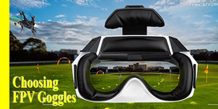
First-person-view (FPV) goggles are all the rage. FPV goggles, allow the wearer to see the flight and the surrounding environment through the drone’s camera.
FPV is an immersive perspective, to say the least, and a growing trend for drone operators beyond the quad-racer set.
So, if you're thinking of purchasing FPV video goggles, there are a few critical elements users should consider before making a purchase.
FPV: flying made easier?
FPV goggles connect via WiFi to the camera mounted on the drone using a series of small adapters and frequencies. Basically, FPV goggles allow the wearer to see the flight and the surrounding environment through the drone’s camera.
This perspective is, of course, appealing to operators for several reasons. Drone operators find that FPV goggles make it easier to fly; obstructions are more easily navigated and shots are more easily captured. Before FPV goggles, certain shots were difficult if not impossible to capture because of the pilots need to see the drone at all times.
Field of View: larger is better
For the ultimate experience, experts recommend FPV goggles with the largest clear field of view (FOV). FOV is defined as “the extent of the observable world that is seen at any given moment.” As such, the larger the degree, the larger the field of view. Preferably, this view should extend to the corners of the display.
FPV goggles, on average, cover a view range between 37 to 60 degrees. For perspective, a 60-degree FOV is similar to watching a 125-inch screen in your living room. The larger the fields of view the more closely it matches the view of the drone camera. It also give the pilot a less distorted view which, of course, helps with flight operations.
The size and weight of goggles
FPV goggles range in size. Some are as small as a pair of sunglasses. Others are as big as a virtual reality headset. Usually, the larger the goggles the larger the viewing screen. However, the weight and comfort of the headset is also an important consideration.
Heavier goggles can be cumbersome and difficult to wear over long periods of time. Some users can even experience strain along the back of the neck, bridge of the nose, and eye sockets.
Smaller goggles are easier to wear but some can feel cheaply constructed. For those on the fence about this technology, purchasing a more affordable pair is a smart way to figure out if its a match or not. Some operators find that FPV goggles aren't a great option for their flight and personal preferences.
Camera Controls
Some higher-end FPV goggles allow users to manipulate the camera settings – zoom, pan/tilt, the direction it points – if the camera mechanism allows. Keep in mind, not all FPV googles offer camera controls and the ones that do, range in functionality. Either way, the radio controller allows for camera control.
Some users prefer direct camera control via the goggles, others do not. One of the major drawbacks cited by users is the need to take a hand off the radio control, mid-flight, to make any needed camera or goggle display adjustments. Some operators prefer not to have that distraction.
FPV antenna and positioning
All FPV goggles are equipped with antennas and internal transmitters which allow the goggles to sync with the drone’s camera. Antennas are either internally or externally placed. The position of the antenna is vitally important. In fact, the antenna -- and it's position -- is probably one of the most important considerations when choosing FPV Goggles.
Some FPV kits include antennas, which are most often cloverleaf antennas. Cloverleaf are omnidirectional, circular polarized antennas -- which work very well for FPV. Of course, more experienced operators usually choose to alter the setup for a system geared to their particular needs.
Selecting for the application
One of the final considerations when selecting FPV goggles is application.
Racing and agile flight drone operators often choose larger headset style goggles. These also usually have more FOV settings from which to choose. FOV adjustments allow the operator to see more detail and a wider view which is useful for racing and acrobatic flight operations.
Also, FPV goggles with zero latency are crucial to experiencing flight with delay or lag. Quad racers tearing around the track at 80mph, cannot afford to have a delay in the video transmission -- which translates into missed obstacles and crashes.
Smaller goggles are often the choice for everyday and videography operators. These applications require higher resolution and enhanced capture features so it is easier to get great shots. Often, these goggles have reduced FOV in exchange for a better output resolution.
Final considerations
Outside quad racing, adding FPV goggles to a system comes down to personal preference. Though some operators enjoy the immersive experience goggles provide, others simply do not. So, whether to FPV or not? The decision is up to you.
 Call it the ultimate No Drone Fly Zone.
On Aug. 4 the Department of Defense (DoD) released classified guidelines for military personnel. The guidelines focused on available actions in the event of unauthorized drone intrusion over or around a military installation.
The Federal Aviation Administration (FAA), along with other inter-agency partners, helped develop the guidelines. It follows classified guidance that was previously provided to the services and installations in early July.
“Protecting our force remains a top priority and that’s why DoD issued the specific, but classified policy that details how DoD personnel may counter the unmanned aircraft threat,” said United States, Navy Capt. Jeff Davis.

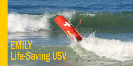
 The Duluth Fire Department in Duluth, Minnesota is considering purchasing the Emergency Integrated Lifesaving LanYard (EMILY) drone.
Hydronalix, located near Tucson, Arizona, created and manufactures the 24-pound unmanned water rescue vehicle.
 Cyber vulnerabilities.
This is the reason given in a U.S. Army memo that orders troops to end all use of DJI drones for operations.
This a huge announcement, and was quite surprising, given that DJI drones are currently the Army’s top choice for an off-the-shelf UAS solution.
The memo released August 2, came from Lt. Gen. Joseph H. Anderson who serves as the Army’s deputy chief of staff for plans and operations. It states, “cease all use, uninstall all DJI applications, remove all batteries/storage media from devices, and secure equipment for follow on direction.”
The memo cited “increased awareness of cyber vulnerabilities associated with DJI products.” No other additional information was provided.
 NuWaves Engineering recently announced the release of the 100 Watt NuPower LS100A01 L & S-band Power Amplifier (PA). It is the latest in the company’s small, lightweight and high-efficiency PA family of products.
With its size, weight, power, and cost (SWaP-C) profile, the NuPower LS100A01 provides significant range extension for communications systems, datalinks, and telemetry systems.
The PA also provides added power for electronic warfare systems such as airborne electronic attack (AEA) at low, medium, or high altitudes, and its low SWAP profile makes it ideal for medium-sized unmanned aircraft systems (UAS).
“For the systems integrator that requires greater communications range, the NuPower LS100A01 will provide a significant improvement with its 100 Watts of output power.” said Jeff Wells, President and CEO of NuWaves Engineering.
 First-person-view (FPV) goggles are all the rage. FPV goggles, allow the wearer to see the flight and the surrounding environment through the drone’s camera.
FPV is an immersive perspective, to say the least, and a growing trend for drone operators beyond the quad-racer set.
So, if you're thinking of purchasing FPV video goggles, there are a few critical elements users should consider before making a purchase.
 By the end of the year, several airports are expected to offer automated authorization for drone operators in controlled airspace. The rest of the nation’s airports will follow suit in 2018.
If successful, these automated authorizations will remove a significant barrier to the rapid expansion of commercial UAS operations.
Today, flights in controlled airspace, at certain times of day, or near sensitive locations require authorization from the FAA. Authorization requests can take up to 90 days and require labor-intensive manual approvals.
Today in