Vendor News

Commercial or Consumer? Comparing the Accuracy of Survey Data Between Two Systems

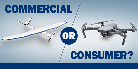
Is there a difference in the accuracy of survey data from a consumer “retail” system versus a commercial system? If so, what is that difference? Over the Summer, the team at Altavian -- manufacturer of the Nova F7200 -- decided to find out.  

Commercial or Consumer?

For a variety of application, including aerial data collection, commercial UAV systems are believed to far exceed the capabilities of a retail drone. However, few surveyors have the luxury of comparing a commercial versus a consumer platform in a real-world environment. So, the Altavian Team decided to run a data collection survey test between a DJI Mavic Pro and an Altavian Nova F7200. The end result? The Nova F7200 produced data ten times more accurate than the Mavic in both horizontal and vertical deviation.  

The control: traditional ground survey

Establishing a reliable control for data comparison was a critical aspect of the experiment. The team decided on a traditional ground survey to serve as the data control baseline. Below is an overview of the ground survey. Equipment used
  • Trimble R7 GNSS RTK Rover
  • Trimble Zephyr Geodetic Antenna
  • Leica TCR405 Power
  • Leica Sprinter
Survey Description This survey established ground control for comparing the survey accuracy of drone data collected by a DJI Mavic Pro and Altavian’s Nova F7200 equipped with an MP-22 payload. Collection of Control The rover was placed on both the South Points for four hours each. The resulting coordinate error are LAT error at .005 m., LONG error .009 m., and ELEV error .033 m. (point 1). For (point 2) LAT error at .006 m., LONG error at .021 m., and ELEV error at .042 m. Survey Procedure The survey points were 8’’ spikes driven through checked linoleum tiles. The points were shot using a Leica TCR405 total station. The elevations were collected using a Leica Sprinter. Survey Results The vertical survey ended with a misclosure of .0095 m. Each aircraft collected two sets of data which the team compared to  With previously established Ground Control Points (GCP) from the ground survey, there was a clear way to determine how the accuracy of consumer and commercial systems stacked up.  

Retail System: DJI Mavic Pro

The team's primary concern was to ensure that the smaller, consumer system had the same GSD as the Nova. To ensure this, the Mavic flew just shy of 60 m. to maintain a calculated GSD of 1.97 cm. The Mavic Flight used 317 photos with a median of 51976 key points per image, and a median of 30452.2 matches per calibrated image. The total flight time for the Mavic was 25 minutes. The data was processed in Pix4Dmapper Pro and then compared to the results from the ground survey. The result was the Mavic had a deviation from the GCPs at 1.9 m. horizontally and 1.22 m. vertically. Finally, the mean RMS error for the Mavic was 0.996 m.  

Commercial System: Nova F7200

Thet team equipped the Nova with their modular MP-22 payload carrying a DSLR Canon SL1 camera. It flew at its standard 90 m. altitude maintaining a GSD of 1.97 cm. The Nova Flight used 238 images with a median of 40199 key points per image, and a median of 25492.3 matches per calibrated image. Total flight time for the Nova was 9 minutes. The data process using Pix4Dmapper Pro was identical to create a comparable data sets between the Mavic and Nova. Once again, the team compared the data to the ground survey. They found that the Nova had a 0.19 m. horizontal and 0.17 m. vertical deviation from the GCPs. The mean RMS error for the Nova was 0.015 m.  

Results: Comparing the Survey Accuracy of Drone Data

When the team examined the two data sets against the accuracy of the ground survey, it revealed a clear winner. The Altavian commercial system thoroughly out paced the consumer system. Now, the benefits of investing in a commercial system were measurable. Also measurable were the risks involved in selecting a consumer drone for such a task. Though consumer drones are a great fit for a number of applications, there are risks involved when choosing such a vehicle for other endeavors. An off-the-shelf consumer drone offers an attractive price tag. However, that price tag also comes with limitations when it comes to the accuracy and fidelity of data that, ultimately, makes it more toy than tool. The advantages of a commercial system like the Nova F7200 for accurate survey data are clear. In the long run, such systems are a safer long-term investment. Commercial drones designed for survey accuracy cut workload down from weeks to days. Such systems enable users to complete projects faster and with more cost efficiency. And, such systems beat the pants off walking that survey line day in day out rain or shine.   Find out more about Altavian's commercial line of solutions at Unmanned Systems Source.

Aeromao’s Aeromapper UAV Line Now Supports Nano Hyperspectral Sensor

Recently, Aeromao Inc., delivered an Aeromapper 300 to the University of Brasilia in Brazil. The customized UAV arrived ready to integrate the Nano-Hyperspectral camera from Headwell Photonics. After initial approval, the team completed the custom integration in just a few weeks.  
Aeromapper UAV

When it comes to finding a UA­­­V dependable enough to trust such an expensive sensor, the Aeromapper UAV line, from Aeromao, are an obvious choice. The UAV's are affordable, dependable, easy to use, offer parachute recover, and a great level of customer support. In addition, the payload bay of the Aeromapper 300 enclosed the Nano hyperspectral camera. Thus, protected by the carbon fiber/Kevlar pod of the aircraft. The Aeromapper 300 comes with a quick swappable mount which can accommodate other sensors, as well as the RGB 24 Mp camera, included.  

Hyperspectral camera

The Headwall’s Nano-Hyperspec® sensor is a completely integrated hyperspectral camera designed for the VNIR (400-1000nm) spectral range, with interchangeable lens capability. Plus, a key advantage of the Nano-Hyperspec is that it also includes 480GB of on-board data collection/storage, plus attached GPS/IMU functionality.   Basic Specifications:
  • Spatial bands: 640
  • Spectral bands: 270
  • Frame rate: 350 Hz (maximum)
  • Dispersion per pixel (nm/pixel): 2.2
  • Lens options: 17mm, 4.8mm, 8mm, 12mm
  • Storage: 480 GB
  • Interface: Gigabit ethernet
  • Weight: 520 grs (excluding lens)
Aeromao Inc., a Canadian company,  is the manufacturer and developer of a series of turnkey unmanned aerial vehicles for mapping, surveying, precision agriculture and remote sensing. The product line includes the Aeromapper 300, Aeromapper TALON, and the Aeromapper EV2. Shop Aeromao's entire line of UAVs at Unmanned Systems Source.

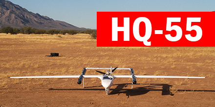
Latitude Engineering Successfully Tests HQ-55

The HQ-55, the newest airframe from Latitude Engineering, recently completed a successfully flight.

This flight marked the completion of a Phase 1 National Oceanic Atmospheric Administration (NOAA) Small Business Innovation Research (SBIR).

On December 12, 2017, the Part 107 compliant aircraft successfully preformed multiple auto-hovers and a short flight.


HQ-55 Phase II

Phase II will involve refinement of the design and testing of the automated launch and recovery from a moving ship. This ship-borne capability will dramatically improve the capabilities of atmospheric and oceanic researchers around the world.

In addition, the vehicle will provide one of the highest payload capacities and range of any part 107 compliant aircraft.

  Find other Latitude Engineering products at Unmanned Systems Source.

Understanding IP Rating Standards and how they Relate to Your Drone

An Ingress Protection Rating, or IP rating, is a laboratory-certified industrial rating for a piece of electronic equipment or an enclosure for electrical equipment. The IP Rating explains the degree of protection provided against debris and water intrusion. It also measures protection against accidental contact -- including body parts like fingers or hands -- to critical components. Developed by the International Electrotechnical Commission (IEC), this internationally recognized rating system is in wide use in Europe and Asia. North America is adopting this standard at a slower pace.  

IP Rating Standards

The standard provides consumers more detailed information than terms like  “waterproof”. The IP rating consists of two digits, each of which measure different forms of environmental influence. The first digit represents protection against intrusion of solid objects, such as dust and debris. The second digit represents protection against ingress of liquids. The higher the value of each digit, the greater the protection. Hence, the digit 0 means no protection is provided. For example, a product rated IP45 provides better protection against environmental factors than a similar product rated IP31.  

IP Ratings and Your Drone

For drones, checking the IP rating of its various parts is a good way to determine the weather tolerance of the UAV.  A sleek design and high IP rating ensure that your motors and fully enclosed components are protected against dust and rain. An IP rating is especially important if you’re looking to fly your drone in rain, near construction sites, or in any situation where weather conditions might change quickly and bring upon adverse conditions. For instance, KDE Direct's KDE-UAS125UVC  is optimized for multi-rotor and single-rotor applications and has an ingress protection rating of IP66. This rating ensures an all-weather and dust-proof operation. It provides complete protection against contact with external debris and projected water (heavy rain) and snow conditions. The current KDEXF-UASHVC ESCs, in operation worldwide, have a certified IP56 rating. This ensures cool-running temperatures and all-weather operations for use in a wide range of harsh environments and commercial/industrial applications. KDE Direct uses the highest-quality materials and manufacturing processes to provide you with multi-rotor and single-rotor motors, electronics, propellers blades, and upgrades to ensure your drone takes off and lands safely.

UgCS Releases Centralized Drone Management Solution for Command Centers

SPH Engineering announces the launch of UgCS centralized drone management solution for Police, Search and Rescue, Firefighter and Security Service Command centers for efficient drone implementation in first response and surveillance operations. This centralized solution was presented at MiliPol 2017.  

How it works

UgCS centralized drone management solution enables Command center operators to track the real-time position of drones in-field. Plus, receive live video streams. Command center operators can also mark points of interest on the shared map. Thus, alerting field drone operators to conduct detailed inspections of certain areas. Centralized management centers can even take manual control over the drone and its camera. UgCS is built to ensure full integration into enterprise infrastructure. Additionally, UgCS centralized drone management solution can integrate with existing Command center software. To enable complete data security, all UgCS components can deploy in a private network to transfer data over a secure connection (no internet required). Also, command centers can access acquired or stored data for detailed incident investigation or to analyze equipment’s usage and plan maintenance.  

Effective management for first responders

“UgCS centralized drone management solution enables effective UAV integration into emergency and security command centers. UgCS and drones provides a live preview of the situation not only to personnel in-field, but for officers at Command center. This enables more precise situation assessment, decision making and effective management of first responder teams, providing more efficient resolution of disaster situation or even saving lives,” said Janis Kuze, SPH Engineering sales director. “A capital city police department is currently using this solution.” Additionally, UgCS enables support for the most popular UAV models. Also, the UgCS centralized drone management solution has no vendor lock. It supports DJI, Yuneec, Lockheed Martin and MAVLink compatible drones (Pixhawk/APM).   Shop UgCS line of solutions at Unmanned Systems Source.

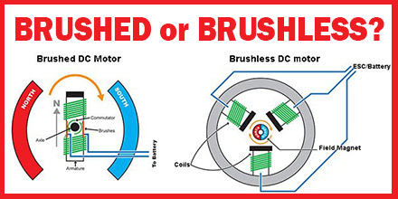
Brushed or Brushless Motor: What’s the Difference?

The biggest difference between brushed and brushless motors, unsurprisingly, is the brush. Otherwise, the principle behind the internal workings of brushed and brushless motors are much the same. As the motor windings energize, it creates a temporary magnetic field to repel or attract permanent magnets. This magnetic force is converted to shaft rotation, allowing the motor to do work. As the shaft rotates, the electric current is routed to different sets of windings. This maintains electromotive repulsion or attraction, forcing the rotor to continually rotate.  

History of Brushed and Brushless Motors

The use of brushed DC motors began in 1856. Today, electrical propulsion, cranes, paper machines and steel rolling mills all use brushed motors. One problem with brushed motors is that the brushes wear down and require frequent replacement. Brush wear became a significant drawback as application demands increased and high-electric discharge noise became an issue. Hence, a new motor was born...the brushless DC motor. Brushless DC motors use electronic speed controller devices and quickly displaced brushed motors for many applications. Advancements in solid state technology in the early 1960s resulted in the invention of the first brushless DC (BLDC) motor in 1962. T.G. Wilson and P.H. Trickey called it a “DC machine with solid state commutation.” The key element of the brushless motor is that it requires no physical commutator, making it the most popular choice for computer disk drives, robotics, and aircrafts.  

Brushless Motor Advantages

Brushless DC motors, with no brushes to wear out, represent a huge leap forward in technology. They also provide significantly higher efficiency and performance. They also offer a lower susceptibility to mechanical wear than their brushed counterparts. Brushless motors offer several other advantages, including:
  • Higher torque to weight ratio
  • Increased torque per watt of power input (increased efficiency)
  • Increased reliability and lower maintenance requirements
  • Reduced operational and mechanical noise
  • Longer lifespan (no brush and commutator erosion)
  • Elimination of ionizing sparks from the commutator (ESD)
  • Near-elimination of electromagnetic interference (EMI)

Today's Brushless Motors

Despite their reliability, the initial downside to early brushless motors was that they could not generate a great deal of power. When better permanent magnet materials became available in the 1980s, they enabled brushless motors to generate as much (or more) power as the previous brush motors on the market. In the late 80s, Robert E. Lordo built the first large-scale brushless DC motor with ten (10)  times the power of the earlier brushless motors. Today’s brushless motors solve many limitations of brushed motors by combining a higher output power, smaller size and weight, better heat dissipation and efficiency, wider operating speed ranges, and very low electrical noise operation. Brushless motors have no electrical contacts designed for wear, providing the greatest advantage in reliability and reduced maintenance intervals for commercial and industrial applications.  

KDE Direct Brushless Motors

Designed and engineered in the United States, KDE Direct’s brushless motors provide best-in-class power, performance, and efficiency. From design redundancy standards and fail-safes to payload capacity and thrust performance, KDE Direct motors are engineered for longer flight times, higher efficiency and higher payloads that push the limits of today’s technology. The KDE Direct UAS Multi-Rotor Brushless Motor Series presents high-quality and engineered motors specific for multi-rotor and UAS applications. The series was designed to provide market-leading performance and zero-vibration operation for hours of maintenance-free usage and market-leading performance. Shop KDE Direct's complete Brushless Motor Series at Unmanned Systems Source.