Vendor News

PPK vs. RTK: When do you choose one over the other?

PPK vs. RTKUAS vendors targeting markets from commercial survey to agriculture are fielding systems with real-time kinematic GNSS (RTK) capability. In principle, RTK promises accuracies at the 1-3cm level. The main purpose is to minimize or eliminate the need for ground control points, thereby reducing cost. Altavian uses GNSS receivers upgradeable to RTK operation, but favors another approach for this level of accuracy: post-processed kinematic (PPK). There are a couple of reasons why:
  1. RTK requires a GNSS base station equipped with a transmitter with a reliable link to a fairly dynamic moving platform.
  2. The rover (on the UAS) itself requires a dedicated receiver for the corrections.
These primary reasons carry some further implications for the cost of deployment, especially when considered against PPK.  

PPK vs.RTK

RTK operations not only require a stationary base station, but it must be located at a known control point. Provided the base station is deployed for long enough periods of time, this is not too much of a problem. The base station’s precise location can be determined post-mission if no control points are already present. In this case, a global shift of the aircraft’s trajectory must be done once the position of the base station is determined, taking away some of the benefits of a ‘real-time’ solution. PPK requires a base station as well. But in many cases, at least in the Eastern US, the public CORS network may be dense enough to provide a base station reasonably close to your project. But, it’s likely you will need a base station of your own. This represents slightly less investment in an over-the-air link to the rover. However, it comes with the possibility of loss-of-lock.  

Losing Lock

In both RTK and PPK, when the rover loses lock, a new integer ambiguity resolution procedure must be initiated. The advantage of PPK is that the search can proceed from previous and future data relative to that instant. Additionally, forward and reverse solutions in PPK are optimally combined and give an estimate of a solution’s consistency. RTK solutions cannot use data that has not yet been recorded. If you want to eliminate ground control points and you chose an RTK system, there is no external information for basing accuracy estimates. Finally, it is worth noting that antennas light enough to be mounted on a small UAS are not geodetic-grade and are not likely calibrated for phase-center variation (PCV), let alone the actual location of the phase center. This means that you might get a reported solution accuracy of 2cm, but it could easily be very misleading. With a PPK solution, at least you can see if the forward and reverse solutions agree within certain bounds (and we acknowledge this is a very limited vote of confidence for any kinematic solution, but it’s better than nothing).  

Conclusion

Ultimately, there is no replacement for real ground truth, especially if your data product must be certified to a specific level of accuracy. However, strategies to minimize the requirements on GCPs can vary widely in their effectiveness, depending on your needs. If positional accuracies of a few decimeters are acceptable, real-time L-band corrections through a subscription service such as TerraStar-D are very attractive alternatives that require no base stations at all. You can find and shop Altavian's line of solutions at Unmanned Systems Source.

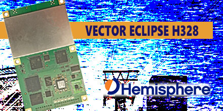
Hemisphere introduces the Vector Eclipse H328 a low-power, high-precision, position and heading OEM board

Hemisphere GNSS recently announced the Vector Eclipse H328, the next offering in the company’s line of new and refreshed, low-power, high-precision, positioning and heading OEM boards. The multi-frequency, multi-GNSS H328 is an all signals receiver board. It includes Hemisphere’s new hardware platform and integrates Atlas GNSS Global Correction Service.  

New hardware platform, higher performance

Designed with this new hardware platform, the overall size, weight, and power consumption of the H328 are reduced. It offers true scalability with centimeter-level accuracy in either single-frequency mode or full performance multi-frequency, multi-GNSS, Atlas-capable mode that supports fast RTK initialization times over long distances. The H328 offers fast accuracy heading of better than 0.17° at 0.5m antenna separation and aiding gyroscope and tilt sensors for temporary GNSS outages. The 60mm x 100mm module with 24-pin and 16-pin headers is a drop-in upgrade for existing designs using this industry standard form factor. The technology platform enables simultaneous tracking of all satellite signals including: GPS, GLONASS P-code, BeiDou, Galileo, and QZSS. This simultaneous tracking makes it robust and reliable. The updated power management system efficiently governs the processor, memory, and ASIC making it ideal for multiple integration applications. The H328 offers flexible and reliable connectivity. It supports Serial, USB (On-The-Go with future firmware upgrade), CAN, Ethernet,and SPI for ease-of-use and integration. It also supports optional output rates of up to 50 Hz.  

Vector Eclipse H328 accuracy

Powered by the Athena GNSS engine, the H328 provides centimeter-level RTK. Athena excels in virtually every environment where high-accuracy GNSS receivers are used. Environments include: open-sky environments, under heavy canopy, and in geographic locations experiencing significant scintillation. Together with SureFix, Hemisphere’s advanced processor, the H328 delivers high-fidelity RTK quality information that results in high precision and reliability. Integrated L-band adds support for Atlas GNSS global corrections for meter to sub decimeter-level accuracy while Tracer technology helps maintain position during correction signal outages. The H328 also uses Hemisphere’s aRTK technology, powered by Atlas. This feature allows the H328 to operate with RTK accuracies when RTK corrections fail. If the H328 is Atlas-subscribed, it will continue to operate at the subscribed service level until RTK is restored. The H328 is designed for robotics, autonomous vehicles, antenna pointing, marine survey, machine control, and any application where high-accuracy positioning and heading is required.   You can shop Hemisphere's line of products at Unmanned Systems Source.

Record-breaking long-distance delivery via drone

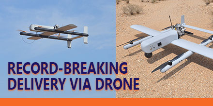
A record was recently set in long-distance delivery via drone. The record-breaking event took place May 5, 2017 and involved several key stakeholders. The Nevada UAS Consortium, dubbed Team Roadrunner, flew a fixed-wing Unmanned Aerial Vehicle (UAV) over 97 miles to Austin, Texas through use of cellular connectivity.  

Delivery via Drone

Launched from an urban location in central Texas, the UAV flew a pre-planned route through National Airspace System (NAS). Team Roadrunner used mobile command and control, a visual observer team, and stationary visual observers equipped with enhanced radios and cell phone communications which allowed the UAV to fly using a cellular communications link. The UAV successfully landed in Austin, Texas and delivered its package. Team Roadrunner consisted of the FAA-designated Nevada UAS Test Site, Volans-i UAS, Latitude UAS, AUV Flight Services. The team also included ground and mobile visual observer support from Embry-Riddle Aeronautical University (ERAU) Worldwide campuses. “This was the most challenging, logistically-intensive, and longest package delivery demonstration recorded to date using cellular technology in the NAS. It allowed us the opportunity to demonstrate innovative capability – a demonstration necessity for the UAS industry,” said Dr. Chris Walach, Director of the FAA-designated Nevada UAS Test Site and Adjunct Assistant Professor, College of Aeronautics at Embry-Riddle Aeronautical University Worldwide. “Assembling a resilient team, being at the right place at the right time with the right technology and entrepreneurial perspective helped us accomplish this mission.” Walach continued, “Drone package delivery in an urban and remote environment is the wave of the future. Nevada is leading and helping grow this major commercial endeavor. These milestones prove that technology enables the safe integration of UAS into the NAS for long-distance and urban package deliveries.” Nevada previously conducted historic package delivery BLOS demonstrations in Hawthorne, Nevada at over 39 miles as well as the first publicly-recorded package delivery to a Reno, Nevada homeowner.  

Safety precautions along the route

The operation included layers of safety. Along the flight path, the team stationed visual observers as well as a mobile team to cover remote areas. “It is very exciting to be part of something truly ground breaking. Integration of students and alumni on similar projects with NIAS in the future extends our outreach to the industry,” said Dr. Scott Burgess, Associate Professor, College of Aeronautics at Embry-Riddle Aeronautical University Worldwide. “Aviation has evolved much since the days of the Wright Brothers. I truly believe that unmanned systems are going to revolutionize the aviation industry and beyond. I am proud that Embry-Riddle faculty, students, and fellow Alumni are actively playing a part in this incredible journey,” said Kandi Windham, Campus Director, Embry-Riddle Aeronautical University Worldwide, Houston, Texas. “This mission was extremely complicated. Ensuring that the UAS met all the performance characteristics was only one piece. We placed great emphasis on flight safety, airworthiness, communication, command and control, air and ground coordination, and VO logistics. The Volans-i, Latitude, AUV Flight Services, and the NIAS team worked extremely well together. Given the complexity and the ultimate success of the mission, it is clear to me that we couldn’t have picked a better team,” said Hannan Parvizian, Volans-i Founder.  

Future of drone delivery

“Creating a safe and thriving drone industry is an incredible challenge, especially when coupled with drone package delivery. The loss of communications during a long flight is a real concern. This mission showed cellular technology can ensure communication with a drone is not lost over a long-distance delivery. The record-breaking success of Team Roadrunner’s aerial package delivery mission proves that diligent testing in complex conditions will lead to drone delivery becoming reality,” said Steve Hill, Executive Director of the Nevada Governor’s Office of Economic Development. The Nevada UAS Test Site is one of seven Federal Aviation Administration-designated UAS Test Sites. The Nevada UAS Test Site in consultation with the Lone Star UAS Test Site helped plan the mission.

Aeromapper Talon Completes Single-Flight Survey of Island in The Maldives

https://www.unmannedsystemssource.com/?s=aeromapper&post_type=product&product_cat=0In December Aeromao Inc., completed a full photogrammetric survey mission of an island with an Aeromapper Talon UAV...in one flight. The survey took place in collaboration with Foresight Surveyors. One of the most unique and exotic islands in the Maldives, the Talon surveyed a total area of approximately 251 acres or 1 Sq. Km. at a GSD of 2cm/pixel.
 

Talon Surveys Island

The Talon UAV flew at a cruise altitude of 100 m AGL and collected 1422 photos with an amazing level of detail. Pix4DMapper software generated a DSM, orthophoto and point cloud. Though the Aeromapper Talon has 2 hour flight endurance capability, the mission finished successfully in only 45 minutes. The UAV flew at a maximum distance from the ground control of 2km. Additionally, the Talon launched and was recovered via parachute from an island roughly 1 km away. The UAV flew without incident. The Aeromapper Talon was not equipped with PPK GNSS system, so 5 GCS points were taken on the island which resulted in a horizontal accuracy of 4.8cm  

The results

The purpose of the survey was to generate an ortho-photo to trace the "as-built" for future developments. Furthermore, the data provided clients with an up-to-date high resolution property map for the project department and decision makers. Also, the othophoto helped with their environmental monitoring and biodiversity mapping.
 

About the Maldives

The Maldives consists of 1,192 coral islands grouped in a double chain of 26 atolls. It spreads over roughly 90,000 square kilometers (35,000 sq mi) and is one of the world’s most dispersed countries. It lies between latitudes 1°S and 8°N, and longitudes 72° and 74°E. Composed of live coral reefs and sand bars, the atolls rise abruptly from the Indian Ocean. These islands are situated on a submarine ridge 960 kilometers (600 mi) long. Maldives is the lowest country in the world. As a result, its natural ground levels average only 2.4 meters (7 ft 10 in) and 1.5 meters (4 ft 11 in) above sea level. However, in areas where construction exists, ground levels have increased several meters.  

About Foresight Surveyors

The first company to introduce unmanned aerial vehicle mapping to the Maldives, Foresight Surveyors chose the Aeromapper Talon because of its ease of use, dependability and affordability. Foresight Surveyors provides a comprehensive range of surveying and survey related consultancy, including: topographical, bathymetry and engineering survey services. The company makes use of traditional techniques and modern technologies to produce accurate data.  

About Aeromao, Inc.

Founded in 2011, Aeromao Inc. is a leading manufacturer of UAVs. Aeromao developed the Aeromapper series of turnkey unmanned aerial vehicles for mapping, surveying, precision agriculture and remote sensing. Canada serves as the company's headquarters. Aeromao Inc. offers a line of products that adapt quickly to market demands and the unique needs of client applications. You can shop the entire line of Aeromapper UAVs at Unmanned System Source.

Phase One announces full integration of aerial cameras with DJI’s M600 and M600 Pro

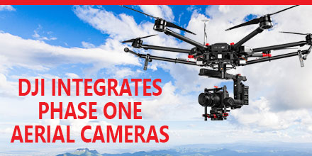
Phase One Industrial recently announced the full integration of its iXU and iXU-RS aerial cameras with DJI’s M600 and M600 Pro drones. Built using DJI’s SDK, this is just the latest drone platform supported by Phase One Industrial. Phase One was the first to deliver 100-megapixel medium format aerial cameras. Since then, Phase One has continued to innovate inspection tools uniquely capable of addressing diverse aerial imaging applications. Those applications range from photogrammetry to critical infrastructure to monitoring projects.  
High quality solution for aerial imaging applications

The aerial cameras’ integration with DJI’s M600 and M600 Pro platforms is delivering high quality solutions for aerial imaging applications. “Using the Phase One Industrial IXU camera with the new Integration package for our DJI M600 drone, the results were extraordinary,” said UAV Flight Systems Manager Tobias Wentzler, Lufthansa Aerial Services. “We achieved millimeter per pixel accuracy, allowing us to inspect the required objects in exquisite detail and lift our mission results and accuracy to a new, high-end level, identifying the subtlest cracks or imperfections that were not visible to conventional inspection methods.” Phase One continues to develop aerial imaging solutions that meet the exacting needs of aerial imaging professionals. “When our clients hire us, they expect the best,” said Ron Chapple, CEO of Aerial Filmworks. “With the new Phase One Industrial aerial cameras integrated with DJI drones, Aerial Filmworks delivers robust performance, highest resolution and finest image quality to support our clients’ cinematic projects. “GEO1, the survey division of Aerial Filmworks, a solutions-driven provider in the electric and gas/oil marketplace, also benefits from this development. Now, we have the right solution to help satisfy our clients’ requirements for the high-resolution data and flight efficiencies.”  

Capabilities include

Phase One Industrial iXU and iXU-RS aerial cameras’ integration with DJI M600 and M600 Pro drone systems include:
  • 100MP and 50MP metric aerial cameras
  • Smart triggering of the camera by waypoints / fixed distance / fixed time
  • Support for mission planning applications (such as DJI Ground Station pro) – for waypoints missions
  • Geo-tagging of all files’ location and gimbal position
  • Dual remote controllers (drone and camera) enable each operator (UAV pilot and camera operator) to focus on their respective mission goals
  • Industrial-grade build of the camera and aerial lenses for use in harsh environments
Also, the integration provides a new iX Capture Mobile application for iOS. This application features an intuitive, user-friendly interface, and support for total remote control of the camera.  

Phase One DJI Integration

Designed using the DJI open platform development tools, iX Capture Mobile offers various operating modes, including:
  • Video Streaming
  • Auto or Manual Capture settings to determine the values of the ISO, shutter speed and aperture
  • Auto capture mode to enable image capturing by waypoints, fix distance or by time intervals
  • Camera control via DJI Lightbridge 2 dials
The iXU and iXU-RS series of high-resolution, metric cameras are known for precision imaging, small size and low weight. In addition, these cameras offer direct integration with other UAV manufacturers, including: Coptersystems, AerialTronics, Pulse Aero, and UMS Skeldar platforms. They also support the workflows of many leading image post processing software, such as: Pix4D, Agisoft, SimActive, and others. Designed to capture images with superior accuracy and quality, Phase One Industrial aerial cameras are capable of covering larger aerial surfaces in less time, resulting in less flight time needed for efficient flying. As such, operators can enjoy both unprecedented visibility and a lower cost by utilizing drones rather than traditional airplane or helicopter methods. In addition, drones offer improved worker safety across challenging environments, including: power line monitoring, inspection of wind turbines, railways, roads, bridges and other civil engineering jobs. Phase One iXU and iXU-RS series camera systems are available immediately from partners worldwide, including Unmanned Systems Source. Camera package prices begin from $29,000 (complete with integration kit and lens). For more information, please contact Unmanned Systems Source.

AsteRx-m2 UAS ultra-low powered GNSS receiver offers unmatched jamming robustness

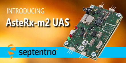
AsteRx-m2 UASMay 8, 2017 - Septentrio, a leading manufacturer of accurate and reliable GNSS solutions, announced the release of the AsteRx-m2 and AsteRx-m2 UAS OEM boards. These OEM boards bring the latest in GNSS positioning to the market with unmatched interference mitigation technology all on ultra-low-power. Septentrio will showcase these OEM boards in Dallas, Texas at AUVSI's Xponential 2017.  

Centimeter-level RTK position accuracy, and more

The credit-card sized AsteRx-m2 and the AsteRx-m2 UAS offer all-in-view multi-frequency, multi-constellation tracking and centimeter-level RTK position accuracy for the lowest power of any comparable receiver. Additionally, the AsteRx-m2 and the AsteRx-m2 UAS can receive TerraStar satellite-based correction signals for PPP positioning. Also, both boards feature Septentrio’s AIM+ interference mitigation system: the most advanced on-board interference mitigation technology on the market. It can suppress the widest variety of interferers, from simple continuous narrowband signals to wideband and pulsed jammers. Increased levels of radio frequency pollution coupled with the intrinsic danger of self-interference in compact systems such as UAS, makes interference mitigation vital to any UAS GNSS system.  

AsteRx-m2 UAS for unmanned systems

The AsteRx-m2 UAS is designed specifically for unmanned systems. It brings plug-and-play compatibility for autopilot software such as ArduPilot and Pixhawk. And event markers can accurately synchronize a camera shutter with GNSS time. In addition, the board can receive power directly from the vehicle power bus via its wide-range power input. The AsteRx-m2 UAS works seamlessly with GeoTagZ software and its SDK library for RPK (ReProcessed Kinematic) offline processing to provide RTK accuracy without the need for ground control points or a real-time datalink. “The market demands increasingly accurate and reliable GNSS positioning systems for inspection, mapping and aerial survey” stated Gustavo Lopez, Product Manager at Septentrio. “Septentrio’s answer is the AsteRx-m2 and the AsteRx-m2 UAS. They offer multi-frequency and multi-constellation tracking as well as robust interference protection all for the lowest power on the market.” If attending XPONENTIAL, find out more about the AsteRx-m2 UAS by stopping by Septentrio's booth, #749, or Unmanned Systems Source at booth #325.  

About Septentrio

Septentrio designs, manufactures and sells high-precision multi frequency multi constellation GPS/GNSS equipment. Receivers, designed by Septentrio, deliver consistently accurate GNSS positions scalable to centimeter-level. They perform solidly even under heavy scintillation or jamming. Receivers are available as OEM boards, housed receivers and smart antennas. Shop Septentrio's line of GNSS receiver solutions at Unmanned Systems Source.