Author - Pamela

KDE Direct Upgrades UAV Electronic Speed Controllers

KDE Direct recently announced new features for their UAS (unmanned aerial system) UVC electronic speed controller (ESC) series and KDE Device Manager V1.32 software. Upgrades include data logging and graphing, stall protection, and motor control optimizations. The new data graphing and logging features are accessible by updating the UVC Series ESC to the latest firmware. During a flight, the UVC Series ESC records the following:
  • Drive Voltage
  • Drive Current
  • Temperature
  • Motor Drive Power
  • Input Throttle
  • Output Throttle
  • RPM
  • Power Consumption
The new KDE Device Manager is customizable and has a new assortment of graphing features to view the ESC data log. The latest update also features a variety of display options, changeable units, and printing. The data log also offers a number of other intuitive features. Users can save data logs as well as upload a data log from a previous flight. Additionally, users can change the data log speed to allow the ESC to record more data. KDE have added the ability to record multiple flights and see all use time. This allows users to keep track of flights in a way that makes the most sense to accomplish their goals. All KDE ESC’s now have the option to turn on Stall Protection. This advanced algorithm allows for the immediate shutdown of electronics during propeller impact or alternate unsafe event. Stall protection also guards the ESC from damage and detects if a propeller is blocked. A number of motor control optimizations have also been added to the KDE Device Manager. The motor control algorithm on KDE’s ESCs have been optimized specifically to particular UAS Multi-Rotor Brushless Motors. This can be accomplished by selecting which motor is being used in the KDE Device Manager, and provides greater efficiency and overall improvements on the motor control.  

Shop KDE Direct's line of ESCs, motors and propellers at Unmanned Systems Source.

VectorNav’s VN-200 Integrated into Precision Imaging Payload

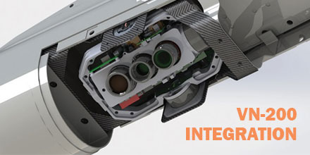
VectorNav announced that its VN-200 GPS-aided inertial navigation system (INS) was selected for integration into Overwatch Imaging‘s TK-series precision imaging payload. The payload is for aerial smart mapping and automatic detection applications for UAVs (unmanned aerial vehicles) and manned aircraft.  

Soda straw effect

Traditional tactical imagery payloads, such as stabilized turret systems, feature electro-optical cameras with small field-of-view angles and high zoom capabilities. Such systems are ideal for tracking target objects from high altitudes; however, they suffer from the “soda straw effect”. When this system is zoomed in to see small targets, only a small area of ground is viewable. When the system is zoomed out to view large areas, smaller details are not visible to the user. As such, stabilized “soda straw” video systems struggle when the application calls for finding small objects in very large areas. They are not an ideal match for industrial inspections or wide-area land management surveys. Overwatch developed an imaging system with  greater image resolution and area coverage for low-altitude manned and unmanned aircraft. In addition, to deal with all the data, Overwatch developed automated image processing software to turn imagery into geospatial intelligence.  

TK-series camera systems

Overwatch Imaging’s TK-series camera systems are designed around a unique, nadir-pointing pitch, roll and yaw stabilized mount. The system features an imaging module that holds application specific sensors and optics. There's also an on-board mini-supercomputer and on-board storage for custom image processing algorithms. To cover large areas with high resolution, engineers developed a step-stare scanning camera motion feature. Compared to traditional mapping systems, this feature increased the per-pass data by 4x. Users can map 4x the amount of ground per pass, increase the resolution by 4x or a combination of both. To implement this advanced imaging technique Overwatch required an INS which could mount to the optical bench.  

INS integration

Mounting the INS directly to the optical bench provided a few advantages. The team no longer needed to rely on aircraft INS for data, it removed the requirement for encoders on the individual axes, and reduced the control system and electronics complexity. Additionally, it provided a smaller overall form factor (critical to small and medium-sized UAS). It was also critical that the INS provide low latency attitude data within 0.1° accuracy for pitch and roll in dynamic conditions. This created a faster workflow, lessened the load on the onboard processor for real-time image stitching and allowed for operation at larger standoff ranges. The engineers at Overwatch surveyed the market and down-selected several inertial products from a variety of suppliers. The focus was to identify a solution with the highest accuracy in the smallest form factor, for the best price. The VectorNav VN-200 Rugged GPS-aided INS out competed all competitive products in each of these categories.  

VN-200

The VN-200’s ability to output accurate position and attitude data at up to 400 Hz and high gyroscope angular rate range (±2000 °/s) allowed the TK-series to maintain accurate attitude estimates while performing the step-stare scanning motions. “VectorNav has an excellent reputation in the marketplace,” said Greg Davis, Founder of Overwatch Imaging. “When a review showed that the VN-200 surpassed other INS solutions in size, cost and performance our choice was clear.” The VN-200 plays a vital role in the TK-series payloads. It provides valuable data for platform stabilization, roll sweeping, step-stare functionality and accurate geolocation of target objects, setting the TK-series apart from its competition. In October 2016 Textron Systems announced the integration of Overwatch Imaging’s TK-7 Firewatch featuring the VN-200 into the Aerosonde Small UAS. The TK-7 Firewatch features multi-megapixel color focal plane array and co-boresighted infrared sensors that enable the system to automatically detect anomalies, such as hot-spots for wildfire mapping. This enables wildland fire crews and forest health managers to more effectively monitor large areas, providing critical analysis, reporting and rapid response capability. Overwatch Imaging’s TK-series is in use in a multitude of new applications -- from vegetation management and infrastructure inspection to target auto-detection and geolocation.  

Shop VectorNav's VN-200 and other sensors at Unmanned Systems Source.

FAA Warns Drone Flyers: Save a Life, Stay Away from Wildfires

If you fly your drone anywhere near a wildfire, you could get someone killed. That’s the stern warning the Federal Aviation Administration (FAA) and U.S. wildland fire agencies have for pilots of unmanned aircraft who interfere with fighting wildfires. Unauthorized drone flights are a serious risk to first responders and anyone in the fire’s path.  
Authorized missions only

Authorized drone missions by the proper authorities can yield valuable information to firefighters. Such missions help detect hotspots, chart a fire’s spread and the progress in controlling a blaze. But when an unauthorized drone is spotted, it may force all authorized helicopter and airplane operations to cease. Unauthorized drone flights create collision hazards to firefighting aircraft. They also distract pilots who are already operating in stressful and challenging conditions. Wildland fire agency reports give a sense of how a single errant drone can disrupt operations: “Drone spotted by pilot at eye level during [helicopter] bucket work… spotted a drone over fire. All helicopter operations shut down…UAS incursion stopped aerial firefighting assets… UAS intrusion into TFR (Temporary Flight Restriction). Helicopters disengaged from fire….” A disruption to any efforts to fight wildfires is incredibly dangerous...and simply not worth it.  

Disruptions can cost a life

“If you own a drone, DO NOT fly near or over a wildfire,” said Dan Elwell, FAA Acting Administrator. “It’s against the law, and firefighting aircraft could be grounded, disrupting time-critical firefighting efforts. Your hobby is not worth another person’s life.” “Most members of the public would never dream of standing in front of a fire engine to stop it from getting to a wildfire, but that’s essentially what they’re doing to aerial firefighting aircraft when they fly a drone over or near a wildfire,” said Jennifer Jones, spokesperson with the U.S. Department of Agriculture Forest Service at the National Interagency Fire Center in Boise, Idaho. If unauthorized drone operations interfere with wildfire suppression, law enforcement, or emergency response efforts, those drone operators could face civil penalties that exceed $20,000 and potential criminal prosecution. Anyone who witnesses or has information about an unauthorized drone flight over or near a wildfire should immediately contact local law enforcement. Deterring interference with first responders, as well as giving way to other aircraft in the sky, becomes more important as drone use expands exponentially. The FAA’s rules for flying unmanned aircraft are clear: Keep your drone away from other aircraft operations, including aerial firefighting missions. You just might save someone’s life.

UgCS Unveils New Search Pattern Planning Feature for UAS

UgCS, provider of mission planning software for unmanned aircraft systems (UAS), together with public safety and disaster response UAS experts Airborne Response, developed a comprehensive search capability for drones. The new feature allows remote pilots to more effectively conduct search and rescue operations using the UgCS platform.  
Software Enhancements

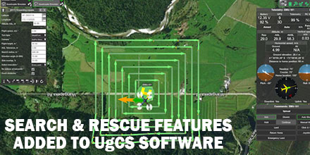
The new enhancements provides users with a variety of quickly customizable search patterns. Such patterns include the “expanding square” and “creeping line” which can easily deploy in emergency and non-emergency situations. Based on the flight altitude input by the operator, the UgCSsoftware automatically calculates key variables. These variable include, the course heading and track spacing necessary to provide the prescribed coverage area for a search target. “The new enhancements to the UgCS mission planning software allow remote pilots, at every skill level, to quickly plan and implement a professional search mission with a UAS,” said Tom “Oaty” Oatmeyer, Chief Pilot at Airborne Response.  

Expert Lends Expertise

Oatmeyer is an air rescue expert with 28 years of experience piloting helicopters for both the U.S. Air Force and the Miami-Dade Fire Rescue department. Oatmeyer worked directly with the UgCS development team to bring the new features to fruition. “The new UgCS search feature is designed to make searching for a target with a drone as simple and reliable as possible,” said Janis Kuze, Sales Director of SPH Engineering. “We look forward to our continued work with Airborne Response to further enhance capabilities and implement additional features.” Airborne Response and UgCS reached an agreement for Airborne Response to offer the UgCS mission planning software, and associated training, to public safety and emergency response professionals throughout the U.S. “When lives are on the line, every second counts,” asserts Oatmeyer.“UgCS now represents another valuable link in the UAS technology chain to enhance the public safety mission.”

US Army Selects Raytheon for Near-Term Counter-UAS Mission

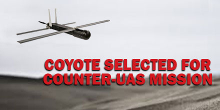
The U.S. Army recently announced the selection of Raytheon's Coyote unmanned aircraft system and the Ku-band Radio Frequency System (KRFS) radar, to counter the escalating threat of enemy UAVs in the skies above the battlefield. Equipped with an advanced seeker and warhead, the Coyote-enabled system can successfully identify and eliminate threat UAVs when paired with an advanced electronically scanned array KRFS radar, which acquires and accurately tracks all sizes of UAS threats. “Enemy unmanned aircraft are among the biggest threats facing our ground troops today,” said Dr. Thomas Bussing, Raytheon Advanced Missile Systems vice president. “Our small, expendable Coyote provides the Army with an affordable and highly effective solution for countering the growing UAS threat.”  

Coyote UAS

The most capable UAS in its class, Coyote is small, expendable and tube-launched. It can deploy from the ground, air or a ship. Coyotes can fly individually or netted together in swarms. They are adaptable for a variety of missions including surveillance, electronic warfare and strike. The versatile Coyote is also used by the National Oceanic and Atmospheric Administration for hurricane tracking and modeling. Raytheon is finalizing development of advanced Coyote variants that will fly faster and farther. Because of urgent operational need, the Army plans to use Coyote as a counter-UAS solution before years' end.  

KRFS Radar

The KRFS radar in use today is a multi-mission radar providing rocket, artillery and mortar, sense and warn, and counter-UAS mission capabilities. Its accuracy enables significant UAS mission performance including precision fire control and UAS swarm scenarios at tactically significant distances. “The warfighter needs a complete mission solution to successfully counter UAS threats,” said Dave Gulla, Raytheon Mission Systems and Sensors vice president. “Our quickly transportable system that tracks low-swarming threats with KRFS and eliminates those threats with Coyote, is a game changer for the U.S. Army.” To date, Raytheon has delivered 40 KRFS radars with more than 32 deployed by the Army. Furthermore, it is upgrading the systems for extending capability and ensuring support of the soldier beyond 2025.

FAA Summer Webinar Series about Waivers Continues with Dark Night: Part I and II

The Federal Aviation Administration (FAA) continues its Summer Webinar Series with Dark Night Part I and Part II. These webinars are no-cost. Any drone operator who is interested in obtaining a daylight operations waiver (107.29) to conduct night-time operations is welcome to attend. Due to heavy demand, the FAA lifted capacity restrictions. Now, both registered and non-registered individuals are invited to login.  

Dark Night: Part I

Dark Night: Part I is on Tuesday, July 24 at 1 pm EST. Discussion centers around the unique challenges involved with operating at night. Additionally, the webinar aims to help operators understand how best to describe the proposed operation -- as is required in the Waiver Safety Explanation Guidelines (WSEG). The one-hour webinar includes time for attendees to ask FAA experts about the application process.  

Dark Night Part II

Dark Night: Part II is on Thursday, July 26 at 1 pm. The topics covered include questions 2-5 of the WSEG. The webinar runs for 30-minutes.  

Accessing the Webinar

The FAA's Summer Webinar Series is hosted entirely online through Adobe Connect. The FAA encourages attendees to login at least 15-minutes prior to the webinar. Those interested in attending can connect via two methods:
  1. Download the Adobe Connect smartphone app and click here. Select the "Enter as a Guest" option; provide a Name and click, "Enter Room".
  2. Officially register for the Summer Webinar Series, by clicking here.
Keep in mind, playback media requires flash. Check to ensure your device has the latest version of Adobe Flash Player. To submit questions to the FAA experts, ensure your microphone works. Participants can always refer to the Adobe Connect How-To guide (PDF). The Summer Series Webinars are free of charge.  

Future Webinars Include:

The FAA began the Summer Webinar Series to help drone operators submit better waiver requests. Each webinar is live and allows attendees to ask FAA experts waiver questions. Upcoming webinars, include: August 7 @ 1 pm EST The Good, The Bad, The Ugly - Using real examples, this session reviews the differences between a success and unsuccessful waiver application. August 21 @ 1 pm EST: Beyond Visual Line of Sight - Why is this so difficult to obtain? This episode focuses on the "holy grail" of waivers. September 4 @ 1 pm EST: Operating Limitations: Altitude - Learn how to fly above the 400' altitude ceiling with an operation limitation (altitude) waiver. September 18 @ 1 pm EST Operations Over People - Why are there so few approvals for this waiver? Session addresses the mitigation necessary to ensure an operation doesn't endanger people on the ground  

Past Webinars

Drone operators who missed previous sessions of the series are in luck. Operators can view each webinar via the FAA's official YouTube channel. Past webinars, include: Where is my Waiver - Find out what is involved in the waiver application process. Learn how to apply for what you really want. Risky Business - Successful waivers include detailed risk assessments. Learn how to identify hazards, assess the risk they pose to your operation and develop methods to reduce the identified risk. Just the Facts - The importance of good data to support your proposed operation and safety case is key to successfully applying for a waiver. Learn why Requests for Information positively support your application and what to do in your safety mitigation.